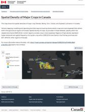
This map shows the spatial densities of major crop (Cereals, Barley, Corn, Canola, and Soybean) cultivation in Canada.
Various mapping, modeling and reporting activities require knowing where certain crops are more expected than others within the agricultural regions of Canada. Spatial density of crops, as provided in these datasets, specify within the related time frame (2009-2016) in which regions a certain crop is more expected. Regions of high density represent higher temporal and spatial frequency of a certain crop within 2009-2016 time frame in the Prairies provinces and 2011-2016 for other regions of Canada.
For more information about the data, visit: https://open.canada.ca/data/en/dataset/fdf82539-5a74-440b-86ef-a16b7801c706
- agriculture
- Crops Cereals
- barley
- corn
- canola
- wheat
- pulses
- Oats and Soybean
Did you find this app useful?
35 votes with an average of 3.48
- Spatial Density of Major Crops - Agriculture and Agri-Food Canada
- Spatial Density of Barley in Canada
- Spatial Density of Canola in Canada
- Spatial Density of Cereals in Canada
- Spatial Density of Corn in Canada
- Spatial Density of Oats in Canada
- Spatial Density of Pulses in Canada
- Spatial Density of Soybean in Canada
- Spatial Density of Wheat in Canada
- Canadian Drought Monitor